Sosto

Information
| Date: | 27 October 2021 |
| Maximum height: | 2221 m |
| Difference in height: | 530 m |
| Length: | 3 km |
| Kilometers effort: | 10 kmef |
| Duration: | 3 hours |
Difficulties (Automatic translation in english)
Comment (Automatic translation in english)
By now we are at the end of the season, the days are getting shorter and it is no longer the time for long hikes. I am therefore reviving an idea that I have had in mind for many years: that of climbing the Sosto in the Blenio valley. With an altitude difference of just over 500 metres, it is the ideal excursion for this period. It is not to be underestimated, however, given the technical difficulty of the last section.
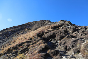
First, passing by the Lago di Luzzone dam, I reach the Passo Muazz, at the entrance to the Val Carassina. I then start walking, following a slight track that heads to the left. Once we enter the forest, the path becomes more evident and immediately begins to climb steeply towards Sosto. Towards an altitude of 1740 metres, some rocks begin to appear on the path, raising the difficulty a little. This lasts approximately until an altitude of 1850 metres, beyond which the path becomes fairly easy again. Twenty metres higher, I reach one of the pylons of the Ofible cable car that connects Olivone to the Luzzone dam. I then continue to climb without great difficulty up to an altitude of 2170 metres, the point where the path ends and the last 50 metres of rock begin. This section, which has a gradient of about 45°, is quite exposed and has some grade II passages. It is also not easy to hold onto the rocks because they are quite crumbly and have inverted grips that you cannot hold onto well. The normal route, in the first section, climbs to the left and then continues straight on towards the summit ridge. From time to time there are a few stone cairns and a few pieces of track.
When I reach the ridge, I walk along it all the way to the summit and then continue towards the cross, which is a few metres lower down, high above Olivone.
For the return journey I follow the same route as on the outward journey.
Water (Automatic translation in english)
The only source of water is at the Muazz Pass, near the alp, where there is a fountain that was, however, rightly closed at this time.


Comments (2)
Quando sono salito io i segni blu non c'erano.
Devono averli appena fatti.
La traccia per gli ultimi 50 metri è segnalata con bollini blu.
Splendida vista finale.