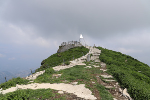
Monte Generoso

Information
| Date: | 1 June 2022 |
| Maximum height: | 1701 m |
| Difference in height: | 840 m |
| Length: | 9.5 km |
| Kilometers effort: | 20.7 kmef |
| Duration: | 5 hours and 30 minutes |
Difficulties (Automatic translation in english)

|
All along the route (T1 the stretch of road between Scudellate and Roncapiano). |
Comment (Automatic translation in english)
I have already climbed Monte Generoso from different directions but never from the Valle di Muggio.
This time I therefore start my walk from Scudellate, which can be reached by bus or by car (few parking spaces available). After crossing the village, I first follow the path to Erbonne until I reach the chapel of Sant'Antonio. Immediately after the chapel there is a diversion on the left that begins to climb towards Alpe di Sella. At an altitude of 970 metres I reach a roccolo, an ancient construction that was once used to catch birds using nets hidden in the surrounding trees. Continuing the ascent I reach the Alpe di Sella and immediately afterwards I reach the border between Switzerland and Italy, which I follow until I reach the summit of Monte Generoso.
For the return journey, I decided to take an alternative route and first descend along the path that leads to Bellavista and then detour towards Alpe Génor. Once past the alp I reach Nadigh where there is an old nevera, a building that was once filled with snow to create a sort of refrigerator in which food was stored. From there I then follow the path that descends to Roncapiano where I stop for a moment to observe the oratory of Beata Giovanna Falconieri. I then continue along the road until I return to my starting point.
Water (Automatic translation in english)
There is a fountain in Scudellate and one in Roncapiano.


Comments (0)