Madone

Information
| Date: | 4 September 2023 |
| Maximum height: | 2395 m |
| Difference in height: | 1640 m |
| Length: | 21 km |
| Kilometers effort: | 42.8 kmef |
| Duration: | 10 hours |
| Huts reached: | Capanna Borgna |
Difficulties (Automatic translation in english)
Comment (Automatic translation in english)
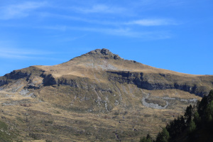
There are many Madoni in Ticino. One of the most famous is at the top of the Val della Porta, a short distance from the Pizzo di Vogorno, clearly visible when crossing the Monte Ceneri Pass to the north.
To reach it I would have liked to start from the Monti della Motta, above Cugnasco-Gerra, where there is a large car park. Unfortunately, since 2020 they have put up a no-entry sign immediately after the fork at an altitude of 1026 metres, so it is no longer possible to climb there. However, there is only room for 4-5 cars there. Fortunately, I find a parking space.
I then start walking along the asphalt road, which is almost 3 kilometres long, to the Monti della Gana. I then take the path up to the Alpe di Sassello and continue on to the Forcola. Once reached, the Val della Porta opens up before me, at the bottom of which the Madone is now finally visible. I then continue to climb until I reach the Capanna Borgna along a beautiful path, but about halfway up, there is a 90 metre descent. The hut currently consists of two buildings while two others are being renovated and will be added in the future. The existing huts will then have their sheet metal roofs replaced with a nicer one made of poplar, thus restoring the buildings to their original appearance. A truly commendable job carried out by the volunteers of the Società Escursionistica Verzaschese.
After a short break, I set off again in the direction of Bocchetta di Cazzane, following the path that starts immediately behind the hut. Normally one would leave it at an altitude of 2070 metres to head west and thus reach the Madone by climbing its southern slope. I, however, want to reach the vent first and so I continue following the path. Once reached, I enter the Moleno Valley for a moment and then leave the path and head left. I then start to climb until I reach the south-east ridge of Madone, which I follow up to an altitude of 2270 metres. At that point, I abandon it and head towards the south side of the mountain until I reach the gully that from altitude 2360 metres rises directly to the summit. After climbing it, finding several grade I climbing passages, I finally reach the summit.
For the return trip, I decide to extend this excursion a little and go to see the Bocchetta di Rognoi. I then descend the gully that I followed on the way up and follow the meadows southwards to an altitude of 2210 metres. At that point, I turn west and following a slight track, I arrive at the second pass of the day. A short break and I start to descend towards the Capanna Borgna following the official path. Unfortunately, the fog begins to rise and I can no longer take photographs. After reaching the hut, following the same path taken in the morning, I return to the Alpe di Sassello and finally to my starting point.
Water (Automatic translation in english)
There are two fountains at Monti della Gana, one at Alpe di Sassello and one at Capanna Borgna. Should the latter be closed, there is also a river not far from the hut.


Comments (0)