
Pian Alto, Camoghè, Pizzo Tom e Pizzo Stabbiello
Information
| Date: | 5 July 2024 |
| Maximum height: | 2442 m |
| Difference in height: | 950 m |
| Length: | 12 km |
| Kilometers effort: | 24.6 kmef |
| Duration: | 6 hours and 30 minutes |
| Lakes reached: | Laghetto a nord del Pizzo Stabbiello |
| Lago di Tom |
Difficulties (Automatic translation in english)

|
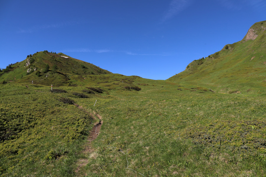
From the Ritom dam up to Pian Alto and then to Bocchetta del Camoghè (T2+ between the altitude of 1990 and 2040 metres). |
|
|
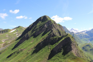
From Bocchetta del Camoghè to the top of Camoghè (with a few short T3 passages). |
|
|
From the Bocchetta del Camoghè to the summit of Pizzo Tom and then to the Bassa della Fontana del Bò (with a T3 passage at the altitude of 2320 metres, west of Pizzo Tom). |

|
From the Bassa to the summit of Pizzo Stabbiello (with a little exposed T3 passage at the altitude of 2326 metres, west of Pizzo Stabbiello). |
|
|
From the Bassa della Fontana del Bò to the trail at the altitude of 2223 metres (with 1 somewhat exposed T3 passage at 2292 metres). |
|
|
The descent to Lake Tom and then the return to the Ritom Dam. |
Comment (Automatic translation in english)
After having done the peaks on the south side of Val Piora last year, this year I dedicate myself to those on the border with Val Canaria.
After reaching the pay car park (11 francs for 6 hours and 15 francs for the whole day) near the Ritom Lake dam, I start walking along the path up to the Bocchetta di Föisc. I then continue following the track that climbs northwards until I reach the first peak of the day, the Pian Alto. After a short break, I begin to follow the easy ridge to the Camoghè Pass, after which I continue following the path that leads to the Bocchetta del Camoghè. At that point I spot a fairly evident track that climbs southwards and I begin to follow it. In a short time I reach the summit of Camoghè where there is a large stone cairn.
I take a short break and descend back to the little vent I had reached earlier and then start to climb towards the third peak of the day, Pizzo Tom. Having reached an altitude of 2300 metres, I abandon the south ridge because it becomes steeper and steeper. I therefore prefer to head further to the left towards a small nozzle located at an altitude of 2324 metres. Once I reach it, I easily climb up the mountain's west ridge to its summit.
Another break and then I begin to descend along the easy ridge that leads to the Bassa della Fontana del Bò. I then continue along the track that climbs northwards until I reach a short, somewhat exposed passage at an altitude of 2326 metres (difficulty T3). Having passed that section, I advance another 170 metres until I reach a plateau, after which I turn right and climb the easy ridge to the summit of Pizzo Stabbiello. During the ascent I have a surprise: towards the north-east I glimpse a small lake that is not marked on the national map. I therefore decide to go and see it. From the summit I first follow the north-east ridge and then abandon it and descend directly towards the small lake. The latter is evidently temporary and at this time is fed by water from the melting snow. Its width, however, is considerable and reaches about 50 metres. I therefore find it strange that it has not been included on the map.
After seeing the lake up close, I cross the entire plateau to the west and then descend again to the Bassa della Fontana del Bò. At that point I take the track that continues southwards and is full of bushes in many places. After about 90 metres I come across a slightly more exposed section (see photo) partly covered with rhododendrons and wild junipers. With difficulty I manage to get through, but only after clinging to the bushes so as not to risk falling down. On the left, in fact, there are several metres of emptiness. This is perhaps the most challenging section of the entire trip.
I then continue south until I reach the official path coming from the Bocchetta del Camoghè. I follow it to the left until I reach Lake Tom, after which I take the road that descends to Lake Ritom. When I reach the lake, I walk along it until I return to the starting point.
Water (Automatic translation in english)
There are two fountains on the way up to Bocchetta di Föisc, one at the altitude of 1872 metres and the other at 1927 metres. There is then one more on the way back along the road from Alpe Ritom to the dam. In addition to this, there is a stream that descends towards Lake Tom from the west.
Map of the Path


Summits
Lakes


")


Comments (0)